
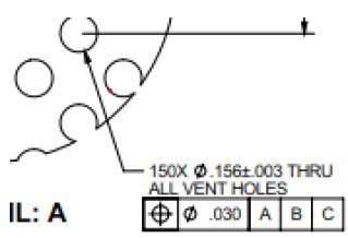
Say you have a perf pattern of holes, similar to the snip below. I would probe each hole, assigning each its own identifier, then, when dimensioning, drop all of the hole idents into the GeoTol position tool for a single group position, instead of 150 position call-outs.
Is there a way to have GeoTol report the max and min hole diameters and max and min position results?
I know that you could dump each dimension into an array, then use the max and min array functions, but I am hoping for a solution within GeoTol itself. Then, by extension, is there something similar for a group profile?
Thank you in advance.
